
WFEO, representing the Scientific and Technological Community Major Group (STC MG) at the UN, has successfully hosted a side event of the UN High-Level Political Forum (HLPF) virtually with the theme “How the Lever of Science and Technology Can Be Used in Peri-urban and Urban Environments to Advance Sustainable Development: the Case of Implementing Geospatial Engineering” on 9th July 2020. This side event was supported by the Permanent Mission of the People’s Republic of China to the UN.
The recording of the side event is available in this page.
The event included the launch of a white paper “The value of Integrated Geospatial and Building Information Modelling (BIM) solutions to advance the United Nations Sustainable Development Goals (Agenda 2030) with specific focus on resilient infrastructure” (available in this page).
The project was the result of collaboration between the World Federation of Engineering Organisations, the World Geospatial Industry Council (WGIC) and the United Nations Committee of Experts on Global Geospatial Information Management (UN-GGIM). The object was to demonstrate the pathways and success stories for the implementation of a wide range of geospatial technologies for sustainable development. The work of the WGIC AEC Working Group was led by Ms. Ananya Narain and supported by Eric DesRoche and Robert Mankowski and the contributions of WFEO led by Dr. Marlene Kanga, WFEO – President, 2017-2019 and UN-GGIM led by Mr Gregory Scott was acknowledged.
Speakers demonstrated how one of the four major levers of sustainable development – science and engineering – can be used in urban environments (cities) as one of the six major pathways to accelerate sustainable development.
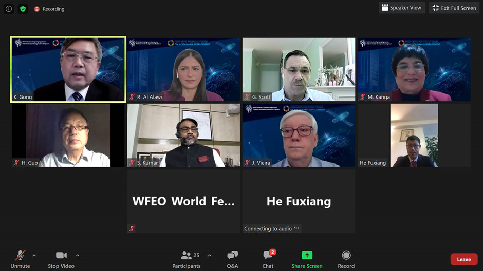
Prof. GONG Ke, President of WFEO, moderated the event. In the beginning, Mr. HE Fuxiang, counsellor of Permanent Mission of the People’s Republic of China to the UN made an address strengthening engineering as an important engine and STI’s pivotal role in advancing sustainable development.
Mr Sanjay Kumar, CEO of World Geospatial Industry Council (WGIC), launched the white paper and explained the imperative of Resilient Infrastructure and GEOBIM solutions (see the presentation).
Mr Gregory Scott, Secretariat of UN-GGIM, spoke on “Geospatial Engineering: A Lever to Assist Developing Countries to Bridge the Geospatial Digital Divide” (see the presentation). He discussed technology enablers, data and integration dimensions of bridging the geospatial digital divide and achieving the SDGs, and introduced the Integrated Geospatial Information Framework.
Dr. Marlene Kanga, Immediate Past President of WFEO, and project leader for WFEO on the white paper spoke on “Implementation of Geospatial Technologies for Sustainable and Smart Cities” (see the presentation) and the key objective of WFEO to advance UN Sustainable Development Goals through engineering. The project was an example of capacity building in such advanced technologies with case studies using live data of successful implementation.
Prof. GUO Huadong, Chief scientist of CASEarth, and member of 10-Member Group to Support the Technology Facilitation Mechanism (TFM), spoke about “Big Earth Data for Urban and Peri-urban Sustainable Development” (see the presentation), and the “Big Earth Data Science Engineering Project” (CASEarth) of Chinese Academy of Sciences and how big earth data advances the urban and peri-urban sustainable development with 8 themes, including urban public transportation, road network, open public space, heritage protection, urbanization, pollution, public health, and disaster prevention & mitigation.
Prof. José Vieira, President-Elect of WFEO, and Prof. Raida Al-Alawi, Director of Technology Development at BFG International, Chair of ICT committee of the Federation of Arab Engineers commented on the speeches, especially the white paper.
Brief Introduction of the white paper:
For more information:
WFEO-WGIC-UNGGIM White paper: Geospatial Engg Sustainable Development
WFEO side event page on HLPF website
JUL
2020